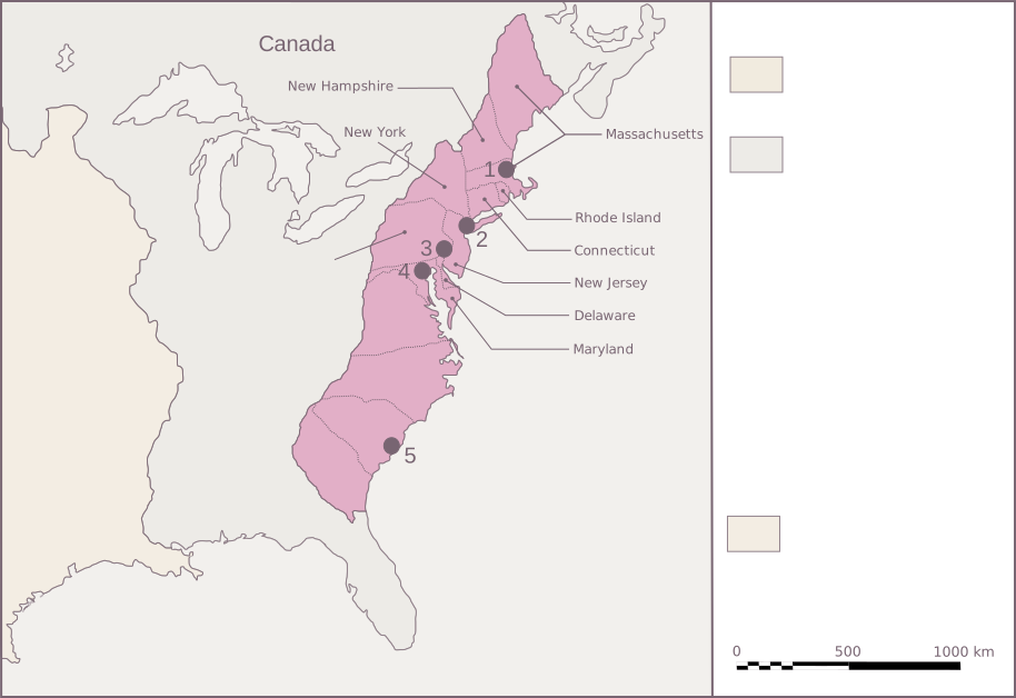
Colonies that declared independence together in 1776
8
Moments showing how cooperation became constitutional union
2
Connected views: historical geography and the Exodus story
01 · Watch the union take shape
Move through the years. Look at who joins.
Choose a date, then a colony on the map or in the list. Each date asks a specific question about attendance, a vote or ratification.
September 1774
Twelve gather; Georgia is absent
Twelve colonies sent delegates to Philadelphia. Georgia did not. This was a gathering to coordinate a response to British measures, before the collective declaration of independence.
The Continental Association turned agreement into coordinated economic action through a boycott and local enforcement committees.
Represented in CongressNot represented in this Congress
Geography adapted from Urban’s 2007 reconstruction of c. 1775, dedicated to the public domain. Pink areas and pins are orientation aids; disputed borders, western claims and Indigenous nations are not fully represented. This is not a map of modern state boundaries. Map source and credit
Middle colonies
PA
Pennsylvania
Represented in Congress
Philadelphia hosted the Continental Congresses and the 1787 Convention. Franklin’s Exodus seal proposal and 1788 essay connect the political and biblical stories.
A shared cause needed common language and action. In 1775 Adams described a biblical sermon moving listeners and a continental fast bringing people into shared observance.
Franklin’s Moses and Pharaoh become a proposed emblem of resistance. Jefferson also proposes Israel guided by cloud and fire. Congress does not adopt the design.
The Massachusetts preamble expressly uses reciprocal covenant language. The Articles and federal Constitution are distinct ways of organizing cooperation among states and citizens.
A people’s departure is followed by questions about law, authority and the road ahead.
→
EXPLICIT ANALOGY · APRIL 8, 1788
Franklin’s thirteen tribes
Franklin retells Moses’s government to argue for ratification. His thirteen-tribe formulation is in the published text; the essay is political advocacy, not an agreed map of colonies onto Hebrew letters.
Thirteen colonies are thirteen political communities.
They are not thirteen original founders or thirteen zodiac signs. Babylon’s twelve chambers around indwelling presence is a separate interpretive diagram. We can compare the movement toward wholeness while preserving what each source actually counts.
The people on this land also included Indigenous nations, enslaved people, women, Loyalists and others whose freedom and participation were unequal. Colonial outlines do not show all of their communities or claims.
The interactive geography is adapted from a modern reconstruction. Compare it with the Library of Congress’s catalogue record for Sayer and Bennett’s 1776 map of the middle British colonies, based on Pownall’s mapping. The period map covers the middle colonies and surrounding regions; it is not a complete survey of all thirteen.
Evidence and map provenance reviewed November 10, 2026. Stage marks show institutional participation or decisions, not military control or unanimous public opinion.